 |
|
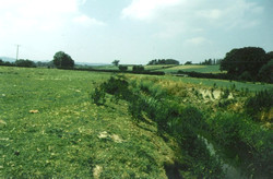
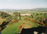 The North wall of the inner ward affords a spectacular view across the low ground where the Battle of Montgomery was fought
|
Cromwellian Britain
|
|
| The town of Montgomery lies in the very east of the Welsh county to which it gives its name, close to Shropshire and the current English border. Founded by the English in the early thirteenth century, the town was largely by-passed by modern development – the canal, railway and main road all followed the flatter, lower-lying Severn valley a little to the west. Accordingly, while Welshpool, Newtown and, to a lesser extent, Llanidloes expanded in the nineteenth and twentieth centuries, the face of Montgomery was little changed. It remains a small border town, more English than Welsh in character, its original medieval street pattern well-preserved and rich in Georgian brick buildings and frontages, a reflection of its heyday as a prosperous and peaceful eighteenth century market town. A century earlier, however, Montgomery was far from peaceful, for it was the scene of probably the largest and bloodiest civil war battle to take place within Wales. Its role in the civil war more closely reflected the town’s medieval military origins than the agricultural prosperity which was to follow. |
|
|
|
Montgomery stands in a strategically important area, a key frontier zone, which had been contested and fortified from the Iron Age onwards. Here, where the lowlands of England and the rolling hills of west Shropshire give way to the uplands and mountains of Wales, the valley of the upper Severn provides one of the few relatively easy routes into mid Wales, an obvious highway for attack from Wales into England and vice versa. Moreover, at this point, just south or upstream of its junction with the lesser River Camlad, there is a natural fording point across the Severn, called Rhydwhyman. From the time of the earliest known human occupation in the area, this was recognised as a key location and was fortified. In the Iron Age, an earthwork hill fort was erected on top of the steeply-sided Ffridd Faldwyn, the highest hill in the vicinity, which stands about one mile south-east of the ford. The Romans built a large earthen auxiliary fort, Forden Gaer, on low ground by the east bank of the Severn, immediately north of the ford. Within a generation of the Norman Conquest, the Norman Earl of Shrewsbury constructed an earthwork and timber motte and bailey castle, Hen Domen, at the north edge of a low ridge, around 500 yards south-east of the ford. The earthwork remains of all three fortifications are still clearly visible; those of Hen Domen have recently been the subject of intensive archaeological excavation. Lastly, in 1223, as part of a drive to recover and strengthen English control of the borderlands in response to continuing Welsh opposition, the new king, Henry III, built a large masonry castle on a lower but steeply-sided eastern spur of the hill upon which the Iron Age fort stands. Although the ford is not within direct line of sight from this new castle, it did provide an uninterrupted view from north to south-east across the rolling plain below. At the same time, the English crown established a new town, Montgomery, on the lower ground immediately east of the castle, with earthworks, walls and gates providing further defence for the new settlement. It was this town and castle, both founded by the crown in the early thirteenth century as part of the conflict between the English and the Welsh, which saw action in the later conflict between the royalists and the parliamentarians. |
||
|
During the opening two years of the civil war, north and mid Wales had
been solidly royalist in allegiance, while much of the northern and
central Marches had been divided. By August 1644, with the capture of
Oswestry and the news of the royalist disaster at Marston Moor in the
north, the parliamentarians felt secure enough in southern Cheshire and
north-western Shropshire to contemplate pushing into Wales, looking to
the Severn valley as the natural highway into the Principality. A
combined parliamentary force under two local commanders, Thomas Mytton
and Sir Thomas Myddleton, raided Welshpool in early August and Newtown
in early September, in both cases taking prisoners and supplies. In the
wake of the successful capture of a royalist powder convoy around
Newtown, the parliamentarians turned their attention to Montgomery. The parliamentarians seem to have entered the town unopposed on 4 September. Indeed, with the Welsh threat long gone by the seventeenth century, the town walls and gates had fallen ruinous and the town was largely undefended. Not so the castle on the hill overlooking the town. |
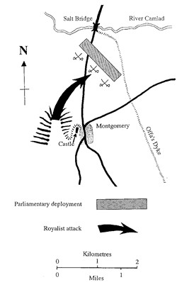
A possible reconstruction of the battle of Montgomery of September 1644. |
|
|
Although Edward I's conquest of Wales in the late thirteenth century had
effectively ended much of the castle’s original purpose, it had been
kept in good order and was periodically refurbished, especially in the
sixteenth century, when it became one of the seats of the crown’s
Council of the Marches. By the 1640s it was the residence of the aged
Edward, Lord Herbert of Chirbury, who lived in state in a grand stone
and brick mansion he had built twenty years before in the middle ward.
However, the entire castle seems to have been in good order and
defensible at the time of the civil war, and it was described by one of
the parliamentarian commanders, Sir John Meldrum, as ‘one of the
goodliest and strongest places that I ever looked upon’.[l] Yet the
parliamentarians were able to capture the fortress with remarkable ease.
Herbert had refused to allow a royalist garrison to be installed and
instead the castle was held by a small personal retinue, nominally for
the king but in reality as a neutral base. Accordingly, when the
parliamentarians approached the castle and demanded its surrender,
Herbert had no stomach for a fight and swiftly entered negotiations. The
parliamentarians offered as inducement both ‘a large sum’ of money and
assurances that Herbert’s possessions, including all his ‘household
stuff, books, trunks and writings’, would be undamaged and would be
conveyed under guard to Herbert’s London house, if he so wished.[2]
These carrots were backed up by a stick, for during the night of the 5th
the parliamentarians fixed petards to the gates to the middle ward and
demanded the castle’s immediate surrender, though repeating their
pledges that no harm would be done to anyone or anything within the
castle and that Herbert’s books and other goods would not be damaged or
taken – evidently he was particularly concerned about the fate of his
library. By 6 September Montgomery castle was in parliament’s hands.
The new parliamentary garrison, under Myddleton, was probably aware from
the outset that the royalists would not allow parliament unhindered
occupation of such a key stronghold and would attempt to recapture
Montgomery at the earliest opportunity. Indeed, almost immediately,
royalist commanders in the region began preparing a counter-attack,
gathering forces from Ludlow, Shrewsbury and other smaller garrisons
which they held in Shropshire. This combined royalist army, numbering
perhaps 2,500 men and commanded by Sir Michael Ernley, approached
Montgomery on 8 September. They surprised and scattered a large part of
the parliamentarian garrison, which had ventured out on a foraging
expedition. Mytton managed to get his 500 foot back into the castle,
while Myddleton’s horse escaped towards Welshpool. Ernley’s royalists
then set about taking the castle by formal siege, apparently digging
siegeworks – earthwork banks and ditches – around the castle. |
||
|
The parliamentary relieving army approached Montgomery from the north on
the evening of 17 September and spent the night ‘in the field that was
most advantageous to us’, probably the low, fairly flat ground flanking
the river Camlad.[3] In the process, they secured an unnamed bridge,
probably spanning the Camlad. Royalist troops had made no attempt to
hold that ground and had instead pulled back. Leaving a small force to
man the siegeworks, Byron had deployed the bulk of his army ‘upon the
mountain above the castle, a place of great advantage for them’[4] –
almost certainly the hill immediately west of and overlooking the
castle, crowned by the remains of the Iron Age hill fort. Battle began
on the 18th when the royalists, noticing that roughly one third of the
parliamentary horse had moved off to forage, swooped down and attacked
their weakened enemies on the plain below. The parliamentary army was
probably drawn up on the low, rolling ground north-north-east of the
town. The remains of Offa’s Dyke and the Camlad offered some protection
to their left wing and rear. Their right wing was more exposed and
vulnerable to outflanking, which might perhaps enable the royalists to
capture Salt Bridge, where the Welshpool road crosses the Camlad, so
cutting off the parliamentarians’ line of retreat. Indeed, several
accounts refer to determined royalist attempts to capture a vital
(though unnamed) bridge, Meldrum writing that the royalists attempted
‘to break through our forces and to make themselves masters of a bridge
we had gained the night before, which would have cut off the passage of
our retreat’.[5] The initial parliamentary response to Byron’s attack, a volley of shot, was delivered too soon, the bullets falling short of the advancing royalists. Unhindered, the king’s men closed on their enemies, firing their initial volley at closer range and to greater effect. The royalist horse threw back their opposite numbers and the royalist foot then gained the upper hand over the parliamentary foot in a close quarter fight – ‘it came to push of pike’.[6] But when victory seemed assured, the royalist advance was first halted and then reversed. The parliamentarian commanders ascribed this change of fortune to the intervention of God and to the resolve of their men to hold their ground. |
|
|
|
According to Meldrum, the parliamentary foot ‘carried themselves more
like lions than men’;[7] other newspaper accounts suggest that it was
the parliamentarian horse regrouping and counter-attacking which turned
the tide of battle. A royalist account alleges that part of the king’s
horse quite unnecessarily turned tail and galloped from the field
through sheer cowardice, an action which understandably unhinged their
colleagues. Possibly the return of that part of the parliamentary horse
which was initially caught away foraging helped turn the tide. Seeing
their colleagues triumphant on the field below, Mytton’s garrison
emerged from the castle and overwhelmed the small royalist force left
manning the trenches. The engagement ended in complete parliamentary
victory and with surviving royalist forces in flight. The
parliamentarians had lost about 40 dead, the royalists 500 dead and a
further 1500 captured. Like most civil war battles, it had been a brief
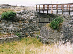
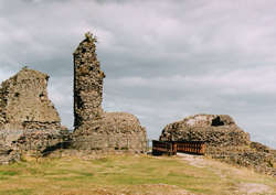
affair – the engagement lasted barely an hour. ln some ways the battle of Montgomery was very significant, for it not only secured parliamentarian control of this key frontier town and castle but also significantly weakened royalism in the area. Royalist regiments and garrisons had been greatly depleted to supply Byron’s army and the crushing defeat, resulting in loss of men and supplies, undermined the royalist hold on Shrewsbury, Chester, Liverpool and other bases. For a time Myddleton was left in command of the new garrison at Montgomery and he used it as a base for capturing Powis castle, outside Welshpool, in October, and Abbey Cwmhir, in Radnorshire, in December. By the end of the year Myddleton had established a parliamentary enclave in this part of mid Wales, centred on the castles of Montgomery and Powis, strengthened by a handful of other outposts and supported by some of the local gentry who had abandoned their former royalist allegiance. On the other hand, the parliamentary high command in London did not accord the Welsh theatre a very high priority at this stage, perhaps rightly judging that royalism in the Midlands and the south of England presented a greater threat. Accordingly, with only limited men and money available, Myddleton was not able to extend parliamentary control far into mid or north Wales. Not until 1645-6 did royalist control over most of Wales falter and collapse. Neither town nor castle of Montgomery played a significant role in the closing stages of the civil war. In summer 1645 parliament briefly lost control of the castle for its then governor, Sir John Price flirted with royalism, only to return to the parliamentarian fold on hearing news of the king’s defeat at Naseby. Montgomery played no part in the renewed civil war of 1648. None the less, in 1649 parliament ordered the castle to be slighted, selectively demolished in order to render it indefensible. The operation was approved by Richard, Lord Herbert, who had succeeded his father a few months before, and he kept a detailed financial account of the work, one of the most detailed accounts of a post-civil war slighting to have survived. The account reveals that this was no crude smash and flatten operation, but rather a careful selective demolition, in the course of which valuable or reusable materials were salvaged. Large scale work took place between late June and early October 1649, employing at its height 150 general labourers as well as miners and craftsmen. Timber, tiles and glass were carefully removed and stored. The work cost £675. Although this account does not reveal how much was made from selling the salvaged materials, similar accounts of the demolition of Wallingford and Pontefract castles suggest that a healthy profit could be expected.[8] Montgomery had not endured heavy sufferings during the civil war. The town seems to have changed hands quickly, with little fighting or bloodshed, while the castle had fallen to parliament by negotiated surrender and an orderly hand-over. However, surviving accounts suggest that Montgomery had not escaped plunder and financial loss. Some time towards the end of the civil war Lord Herbert drew up an account claiming that he had lost something approaching £5000 because of the war, through the actions of both the royalist and parliamentarian armies in plundering his estates of livestock and timber and through non-payment of rents from his tenants who had themselves been plundered and rendered unable to pay. Herbert’s papers also include a similar claim drawn up by or in the name of the inhabitants of the town, claiming losses totalling over £3000. Seventy-five townsmen, from the bailiffs and rector down to shopkeepers and ordinary householders, alleged damage to their houses and losses of cash, personal and household goods, grain and cattle, perpetrated by both the royalist and parliamentarian armies in September 1644. Although doubtless exaggerated, the claims give an indication of the level of damage which could be inflicted in just a few days when rival armies fought for control of a town and its castle. The remains of Montgomery castle stand on the lofty ridge above the town. Recently excavated and consolidated by Cadw, they are open to the public as an open access site. The castle was built on a long, narrow limestone ridge, which runs almost due north-south. The site was protected by steep cliffs to the north and east, and by a shallow valley to the west. Only from the south could it be approached along fairly level ground. The castle defences therefore focus upon hindering attack from the south. An outer barbican, comprising earthworks, a natural rocky outcrop and some masonry walls, is poorly preserved. Next comes the middle ward, its southern entrance protected by a rock cut ditch and a gatehouse. Finally one approaches the inner ward, its southern entrance again protected by a rock cut ditch which separates it from the middle ward and its own large gatehouse. The outer walls of the two wards and their gatehouses are ruinous but survive to a good height. Not so the internal walls which formed the succession of chambers – halls, lodgings, kitchens, bakehouses, stores, a chapel and so on – which were erected within the two wards. Even Herbert’s mansion of the 1620s has largely disappeared. The slighting of 1649 seems to have focused on destroying the barbican and other outer works, filling the two rock cut ditches protecting the middle and inner wards and rendering the two gatehouses indefensible. The recent excavations included laboriously emptying the two ditches. In the course of excavating the inner ditch, several items of obsolete civil war armour were discovered, together with four human skeletons – three males, one teenage female – who perhaps were buried and perished by accident in the course of the 1649 demolition and in-filling. At the same time as he established his new castle, Henry III planted a new town in its shadow, encouraging traders to settle, in part to serve and supply the castle and its royal garrison. A royal charter of 1227 allowed the burgesses to enclose the town with a ditch and other defences. For a time, the main defence seems to have been a timber pallisade, but in the 1270s it was replaced by a complete circuit of stone walls, with at least four defended gateways at the principal entrances to the town. We know from Speed’s map of the town and from other sources that the wall and gates were ruinous before the time of the civil wars and today no masonry survives above ground. However, the earthwork bank and ditch, upon and beside which the town walls stood, can still be traced encircling the town. Curiously even though the steeply-sided hill crowned by the castle defended the west side of the town, the bank, ditches and wall were laboriously built on the west side as well. Running on a north-south alignment about 100 yards west of the castle, this is one of the best preserved sections of the earthwork defences. The original medieval street plan of the town, clearly shown in Speed’s drawing, survives almost unchanged today. Although rich in Georgian brick buildings, notably the town hall and the buildings fronting Broad Street, in many cases the eighteenth century frontages conceal the earlier, timber framed buildings behind. Although subsequently altered, a few of Montgomery’s buildings still clearly show their pre-eighteenth century origins, including the pair of half-timbered houses, once The Plume of Feathers, in Arthur Street, and, further along, the seventeenth century timber-framed Old Bell, now the local museum and exhibition centre. Even more obviously pre-modern is the Church of St Nicholas which dominates the townscape. Founded in the 1220s, but with the two transepts and present chancel added later in the thirteenth century, most of the church remains in essence medieval, despite several nineteenth century restorations. The exception is the tower, entirely rebuilt in 1816. The principal glories of the church include: the fifteenth and sixteenth century nave roof; the twelve medieval choirstalls, nine of them with misericords, in the chancel; the two wooden screens, the western one of the early fifteenth century built for the church, the eastern one from nearby Chirbury Priory and re-erected here when the priory was dissolved; the wooden rood loft, again not original to this church, but probably also saved from Chirbury Priory and installed here; and the two alabaster recumbent effigies of men in armour, now resting on the floor of the south transept, probably of Sir Edmund Mortimer (d 1408) and of an unknown figure dating from c 1500. But of greater relevance to the story of Montgomery in the civil war is the magnificent Elizabethan canopied tomb which occupies the south wall of the south transept. Erected around 1600, it commemorates Richard Herbert (d 1596) and his wife, who in fact remarried, lived until 1627 and is buried elsewhere; beneath the grand figures of the couple, Richard reappears in cadaverous form. The couple’s eight children portrayed in arches behind the main figures include Edward, Lord Herbert of Chirbury, the feeble defender of the castle in 1644, and his younger brother George Herbert, the poet. The church, though rather dark inside, is generally unlocked and open to the public. Although a modern housing development has begun to eat into the former open land on the north-eastern fringes of the old town, the land beyond remains undeveloped, gently rolling farmland stretching to the slight valley of the Camlad and the rising ground beyond. It was over this land that the battle of Montgomery was probably fought. As the fortunes of the two sides ebbed and flowed, with first the royalists and then the parliamentarians gaining the upper hand, it is likely that fighting ranged widely over this area, north-north-east of the town and within a mile of it – that is, in the area between the town and the Camlad. Much of the battle probably took place around or to the east of the road from Montgomery to Forden and on to Welshpool (the B4388). The course of this very prominent, largely straight road probably dates back to late eighteenth century turnpiking, though it is likely that it superseded an earlier road or track running away north from the town. From the north wall of the castle, or the northern end of the promontory upon which the castle stands, the visitor is afforded a splendid view across the entire battlefield and surrounding landscape. A Cromwell Association panel, giving an account of the battle, stands at the northern end of the promontory, beyond the north wall of the castle. Notes. 1. J R Phillips, Memoirs of the Civil War in Wales and the Marches (2 vols, London, 1874), II, 206. 2. W J Smith, The Herbert Correspondence (Cardiff, 1963), p. 115. 3. Phillips, Memoirs, II, 203. 4. Phillips, Memoirs, II, 203. 5. Phillips, Memoirs, II, 205. 6. Phillips, Memoirs, II, 201. 7. Phillips, Memoirs, II, 205. 8. M W Thompson, The Decline of the Castle (Cambridge, 1987), appendix 4. A note on sources. All the main accounts of the battle – by Brereton, Myddleton, Meldrum, Ernley and Trevor – are reproduced by J.R. Phillips, Memoirs of the Civil War in Wales and the Marches (2 vols, London, 1874), II, 201-9. W.J. Smith, The Herbert Correspondence (Cardiff, 1963), pp. 114-19, reproduces the accounts of the circumstances in which, and the terms upon which, Herbert surrendered the castle, together with slightly later correspondence by or about Herbert and the two accounts of the alleged losses of Herbert and of the townspeople. Most of the weekly newspapers give accounts of the battle and its aftermath in their editions of the latter half of September 1644; they are to be found in the British Library, Thomason Tracts. Many of the documents concerning the events of September 1644 were gathered together and printed, with a commentary, in the journal Montgomeryshire Collections 22 (1888). The financial account of the slighting of the castle in 1649 is reproduced as appendix 4 of M.W. Thompson, The Decline of the Castle (Cambridge, 1987). Although some of its details have been superseded by the recent archaeological investigation, the standard guidebook by J.D.K. Lloyd & J.K. Knight, Montgomery Castle (2nd edn, Cardiff, 1981) is still valuable; it usefully reproduces as appendix 2 extracts from the Herbert correspondence relating to the 1649 slighting which first appeared in W.J. Smith’s book. The fruits of the recent archaeological work at the castle have been published in two substantial articles by J.K. Knight, ‘Excavations at Montgomery Castle, Part I: Documentary Evidence, Structures and Excavated Features’ and ‘Excavations at Montgomery Castle, Part II: Metal Finds’, in Archaeologia Cambrensis 141 (1992), pp. 97-180, and 142 (1993), pp. 182-242 respectively. Two brief, modern assessments of the battle have appeared: D.E. Evans, Montgomery, 1644 (n.p., n.d., c 1984-5), and A. Abram, The Battle of Montgomery, 1644 (Bristol, 1993). By Dr Peter Gaunt
|
||
|
|
This site is jointly
maintained by the Cromwell Association and the Cromwell Museum
Huntingdon
|